Product of the Month
December 2015
January 2015
November 2014
October 2014
October 2013
June 2013
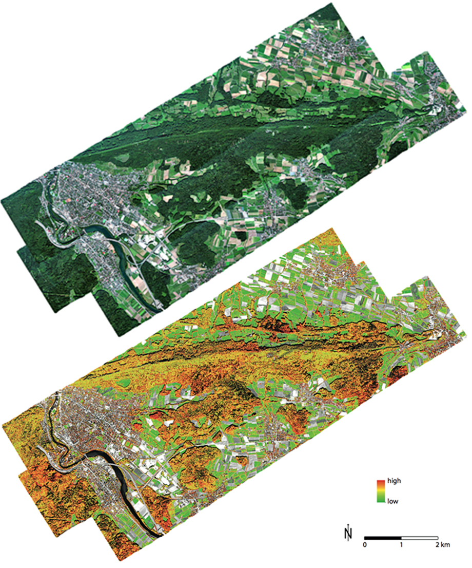
Top: APEX true color mosaic of three flight lines. Bottom: Species richness approximated with the functional attribute diversity (FAD) map based on pre-calculated biochemical plant traits.
Related publication: Braun, D., Damm, A., Hueni, A., Milani, G., Schaepman, M.E. et al. (in preparation). Ecosystem service assessment using imaging spectroscopy: Implications for landscape management and conservation. Remote Sensing in Ecology and Conservation.
Related publication: Braun, D., Damm, A., Hueni, A., Milani, G., Schaepman, M.E. et al. (in preparation). Ecosystem service assessment using imaging spectroscopy: Implications for landscape management and conservation. Remote Sensing in Ecology and Conservation.
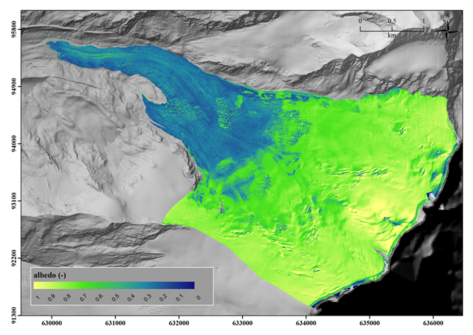
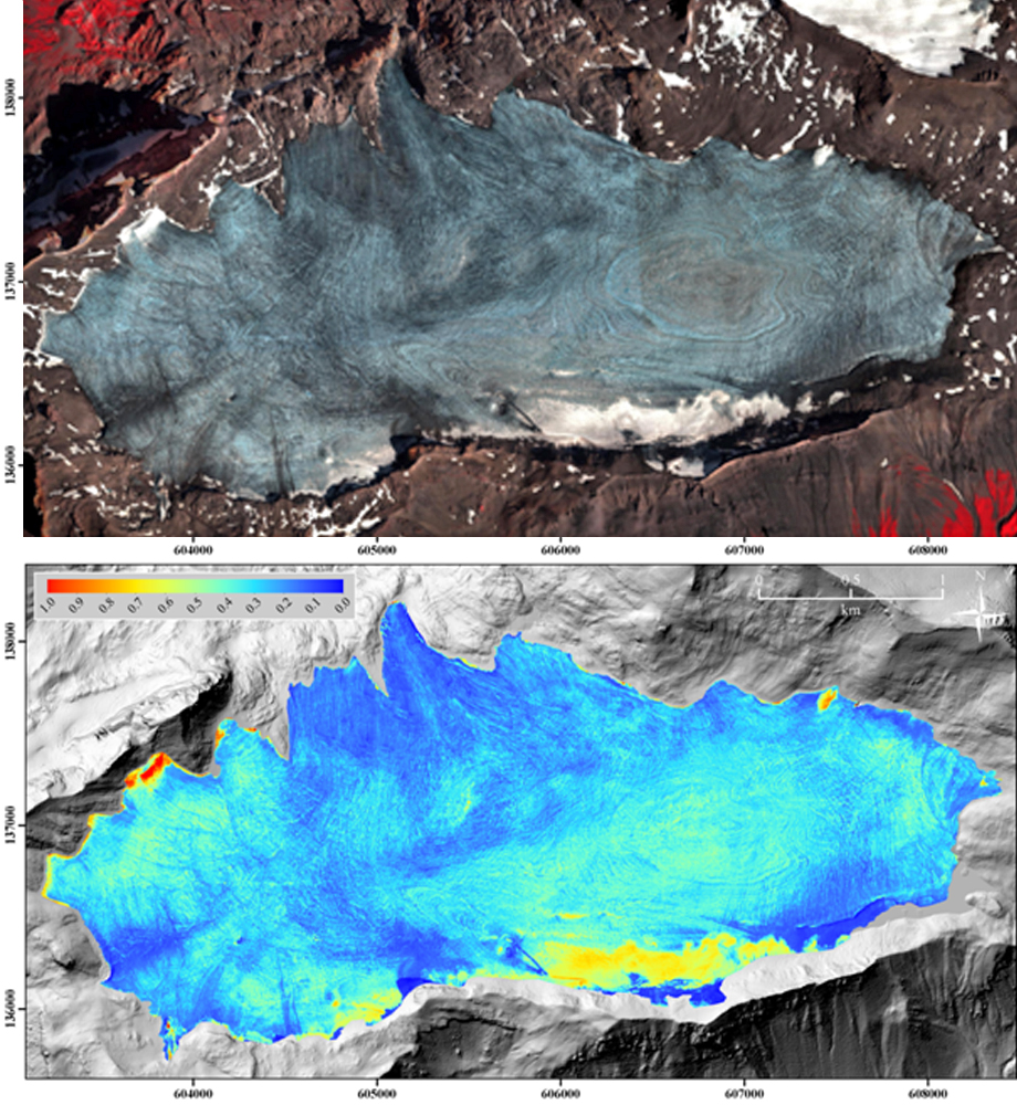
Spectral surface albedo of the Findelen Glacier derived from APEX-HCRF data.
Map was derived using an approach as described in: Naegeli, K, Damm, A., Huss, M, Schaepman, M.E. & Hoelzle, M. (2015). Imaging spectroscopy to assess the composition of ice surface materials and their impact on glacier mass balance. Remote Sensing of Environment, 168, pp. 388-402.
Map was derived using an approach as described in: Naegeli, K, Damm, A., Huss, M, Schaepman, M.E. & Hoelzle, M. (2015). Imaging spectroscopy to assess the composition of ice surface materials and their impact on glacier mass balance. Remote Sensing of Environment, 168, pp. 388-402.
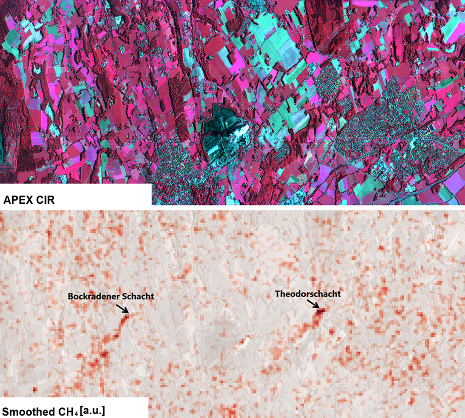
Top: APEX false color composite of Ibbenbueren, Germany, 17 September 2014. Bottom: Methan plumes retrieved from APEX using a matched filter approach.
Credits: D. Brunner and G Kuhlmann, Empa, Duebendorf, Switzerland
Credits: D. Brunner and G Kuhlmann, Empa, Duebendorf, Switzerland
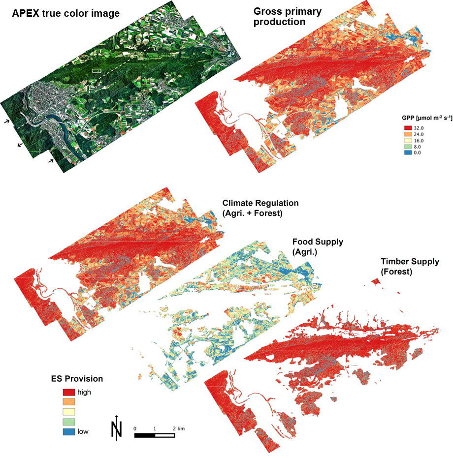
Top-left: APEX true color composite. Top-right: Gross primary production (GPP) derived from maps of sun-induced chlorophyll fluorescence using Monteith’s light use efficiency concept. Bottom: Maps of ecosystem service (ER) provisioning, derived from the GPP using mechanistic models.
Related publication: Braun, D., Damm, A. & Schaepman, M.E. (2014). Mapping ecosystem services - Using remote sensing data to estimate ecosystem service supply. In: 12th Swiss Geoscience Meeting, Fribourg, Switzerland, 21-22 November 2014.
Related publication: Braun, D., Damm, A. & Schaepman, M.E. (2014). Mapping ecosystem services - Using remote sensing data to estimate ecosystem service supply. In: 12th Swiss Geoscience Meeting, Fribourg, Switzerland, 21-22 November 2014.
Top: APEX false color composite, Plaine Morte Glacier, 31 August 2013. Bottom: Glacier surface spectral albedo derived from APEX-HCRF data considering surface reflectance anisotropy.
Related publication: Naegeli, K, Damm, A., Huss, M, Schaepman, M.E. & Hoelzle, M. (2015). Imaging spectroscopy to assess the composition of ice surface materials and their impact on glacier mass balance.Remote Sensing of Environment, 168, pp. 388-402.
Related publication: Naegeli, K, Damm, A., Huss, M, Schaepman, M.E. & Hoelzle, M. (2015). Imaging spectroscopy to assess the composition of ice surface materials and their impact on glacier mass balance.Remote Sensing of Environment, 168, pp. 388-402.
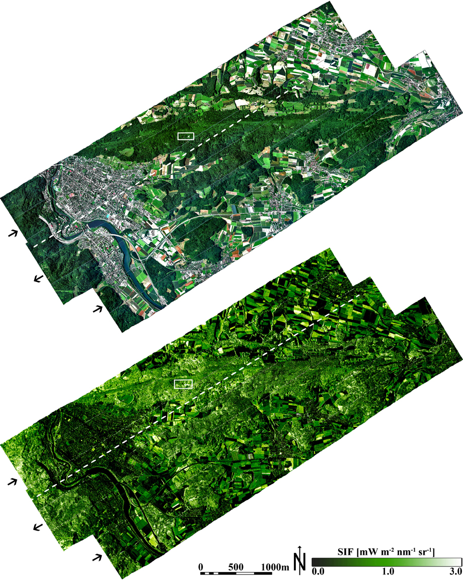
APEX reflectance and SIF image for the Laegeren site acquired at the 26.06 2010, 15:10 UTC. Top: top-of-canopy radiance as true color composite. Bottom: SIF map. The black arrows indicate the flight direction of flight line 1-3. The white boxes indicate the approximate position of the Laegeren flux tower.
Related publication: Damm, A., Guanter, L., Paul-Limoges, E., Van der Tol, C., Hueni, A., Buchmann, N., Eugster, W., Ammann, C. & Schaepman, M.E. (2015). Far-red sun-induced chlorophyll fluorescence shows ecosystem-specific relationships to gross primary production: An assessment based on observational and modeling approaches. Remote Sensing of Environment, 166, pp. 91-105.
Related publication: Damm, A., Guanter, L., Paul-Limoges, E., Van der Tol, C., Hueni, A., Buchmann, N., Eugster, W., Ammann, C. & Schaepman, M.E. (2015). Far-red sun-induced chlorophyll fluorescence shows ecosystem-specific relationships to gross primary production: An assessment based on observational and modeling approaches. Remote Sensing of Environment, 166, pp. 91-105.
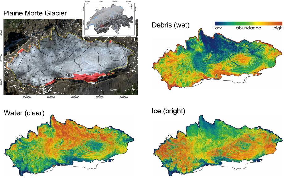
Ice surface materials (bright ice, clear water, debris) were retrieved from APEX data using a spectroscopic approach and in-situ measured reflectance spectra. Data were acquired over the Plaine Morte Glacier (Switzerland) on 31 August 2013.
Related publication: Naegeli, K, Huss, M, Damm, A., de Jong, R., Schaepman, M.E. & Hoelzle, M. (2014). Imaging spectroscopy to assess the composition of ice surface materials and their impact on glacier mass balance. EGU General Assembly, Vienna 2014. Geophysical Research Abstracts, Vol. 16, EGU2014-6282.
Related publication: Naegeli, K, Huss, M, Damm, A., de Jong, R., Schaepman, M.E. & Hoelzle, M. (2014). Imaging spectroscopy to assess the composition of ice surface materials and their impact on glacier mass balance. EGU General Assembly, Vienna 2014. Geophysical Research Abstracts, Vol. 16, EGU2014-6282.
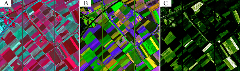
Functional plant traits were retrieved from APEX data flown over the agricultural site Oensingen (Switzerland) on 26 June 2010. Pigments were retrieved using spectral indices, the fluorescence retrieval was based on the Fraunhofer Line Discrimination (FLD) approach. Left: false color composite (CIR), middle: pigment composition map (red=carotenoids, green=chlorophylls, blue=anthocyanins), right: chlorophyll fluorescence. The two vertical bars are artifacts caused by wires glued on the detector entrance slit.
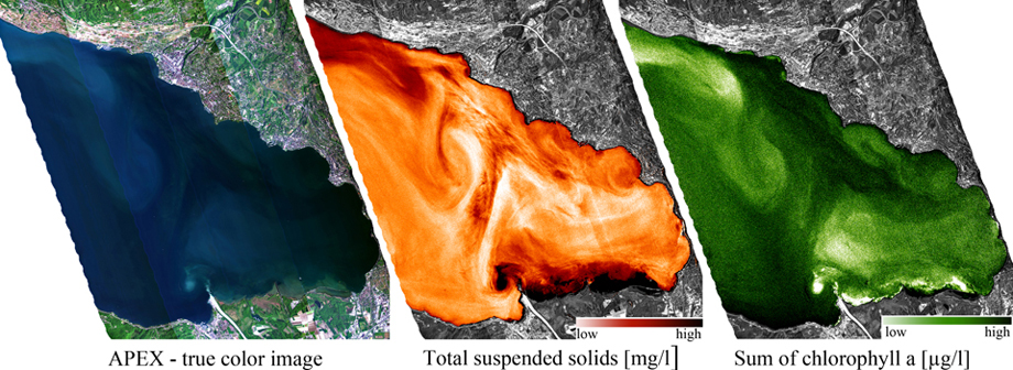
Water products were retrieved from APEX data imaged over Lake Geneva, Switzerland on 14 May 2013. Top: APEX True color image. Middle: Total suspended solids [mg/l], dark colors represent high TSS-concentrations, bright colors low TSS-concentrations. Bottom: Chlorphyll a concentration [µg/l] dark colors represent high Chl-a concentrations, bright colors low Chl-a concentrations
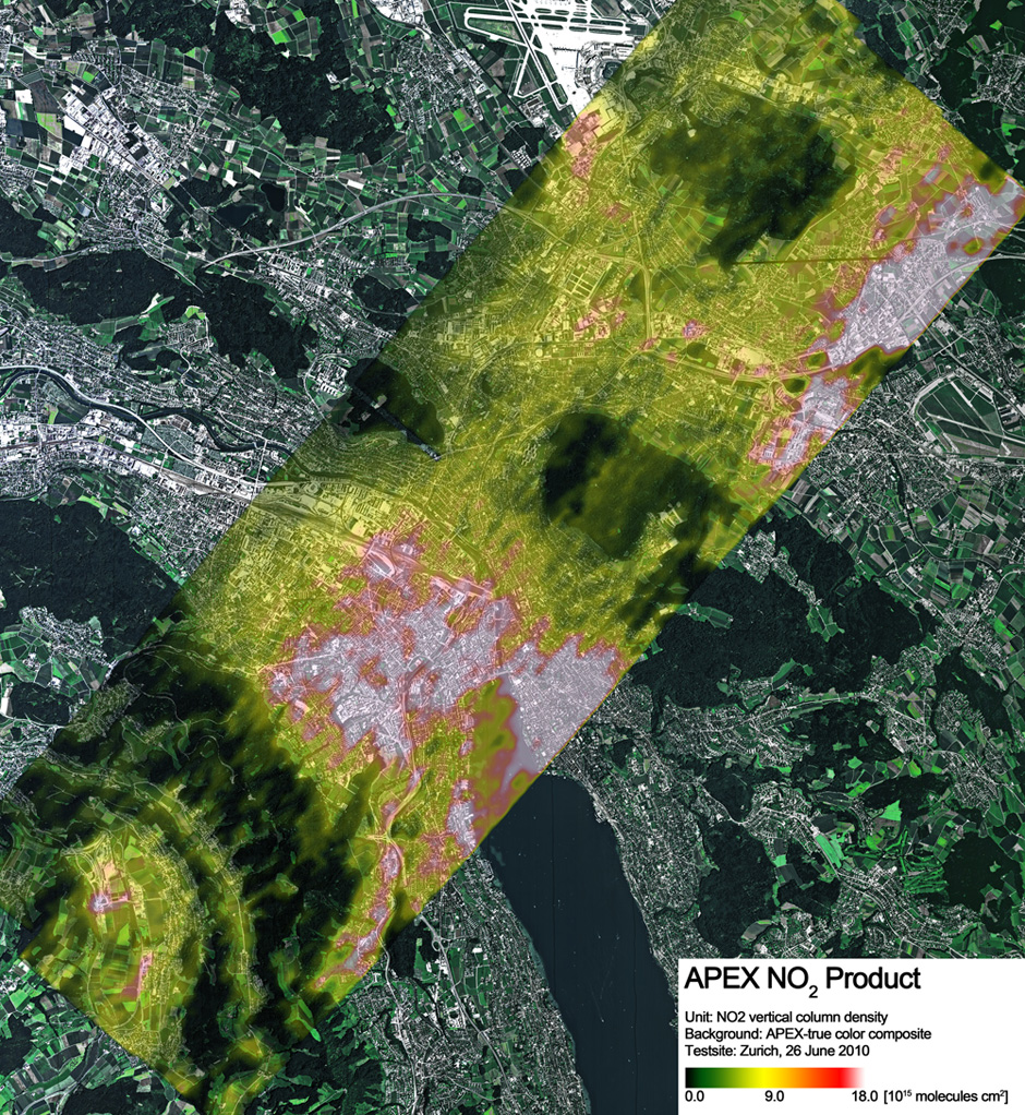
Atmospheric NO2 vertical column densities (VCD) derived from unbinned APEX data over Zurich on 26 June 2010.
Related publication: Popp, C., Brunner, D., Damm, A., Van Roozendael, M., Fayt, C., & Buchmann, B. (2012). High-resolution NO2 remote sensing from the Airborne Prism EXperiment (APEX) imaging spectrometer. Atmospheric Measurement Techniques, 5, 2211-2225. DOI:10.5194/amt-5-2211-2012
Related publication: Popp, C., Brunner, D., Damm, A., Van Roozendael, M., Fayt, C., & Buchmann, B. (2012). High-resolution NO2 remote sensing from the Airborne Prism EXperiment (APEX) imaging spectrometer. Atmospheric Measurement Techniques, 5, 2211-2225. DOI:10.5194/amt-5-2211-2012